BACK
Herbal Urbanism: Beitou 2. Vertical City
To imagine a city by marking an area on a plane surface is often the very first step to misunderstand what it is today. As a symbol of human civilisation, the city consists not only of various human-made infrastructure, but also of million-year formations of rock, hydrological landscape, and the lives of other species within and without its scope. The city is located at some place or region, but its life goes beyond the limits of its administration and the country, of which it is part. The city lives on globally widespread and intricately connected network systems. Together, these systems act not so much like a large web horizontally covering the planet surface, as interconnected volumes stretching vertically around our planet: “From 10,000 metres below the sea, to 35,000 kilometers in orbit above the surface of the earth, the infrastructure that supports urban life has reached unimaginable extents below ground, in the water, and across outer space.”* Complex engineerings to extract subterranean fuel and resources, pipelines laid down on the deep ocean to transport gas and oil, submarine communications cables, across different countries and continents, or large amount of waste dumping on far away, disadvantaged area, buildings stacked up on top of each other, and signals from satellites orbiting the planet — all these interconnected, visible and invisible, systems make modern cities vertical, to replace the horizontal landscape that has dominated human geography since the colonial eras. Hence the arrival of what Eval Weizman called “the vertical 3D sovereignty” which now inevitably occupies the central stage of human civilisation.
Art provides us with an access to comprehend the related changes in perception and in the way we live. As a production of the city, we moderns are in a process of aesthetic transformations while verticality unfolds. We constantly experience the urban verticality through mass media and such representational specifics as documentary films. With the overturn of technology, the old, linear world view is being subverted. At a time when our visual system is increasingly dominated by Google Maps, or the so-called bird’s-eye-view and panorama perspectives, our body’s relationship to the environment undergoes a fundamental shift. Since the mid-nineteenth century, camera has been combined with such aviation vehicles as hot air balloon and plane. From its early usage during the First World War to survey and define what is to be protected and destroyed, to today’s multifaceted functions in transportation, hydraulic engineering, environmental protection, urban planning, archaeology, personal entertainment, etc., aerial photography has also become tools of artistic expression and activist resistance. For artists and activists, it opens up new possibilities to visualise, reflect on and respond to the urban system and its ecology. Once the old, horizontal and stable perspective is overcome, the multi-focal and non-linear perspective now redefines our spatial visions and bodily experiences as well as the imagination of what the world is.
“Herbal Urbanism: Beitou, Part 2” features two works using drone as a means to explore and intervene into the spatiality of the city and as an attempt to reflect on the co-existence of nature and humans. Jui-Kuang CHAO, an artist/activist based in Tainan, extends his body with drone as his doppelganer to open up aerial visual possibilities. In the work of video and photographs, “The Beautiful Longqi Moonworld,” this extended body aviates through the badlands named Longqi Niupu Mudstone Park that the government plans to turn into a polluted waste landfill. As the viewer navigates the magnificent landscape, with its rich bio-diversity and geologic layers, the fear of man-made pollution and destruction looms. Another work by CHAO is a series of photographs titled “The soil is a mirror,” in which the artist documented in different phases how industrial waste was secretly dumped in the farmland. Nicely composed with geometric colour-fields, these landscape photographs echo modernist abstract paintings, while realistically representing illegal waste dump in fish farms and rice-paddies. The drone’s aerial vision reveals the limits of traditional means of representation and transmission, and thereby short-circuits the flow of false information. “Mirror” in the title, furthermore, references to one of the themes of Anthropocece: as we broaden the temporal-spatial scope of vision (aerial perspective of verticality in this work), we would be able to see on the land a reflection of human traces in large scale.
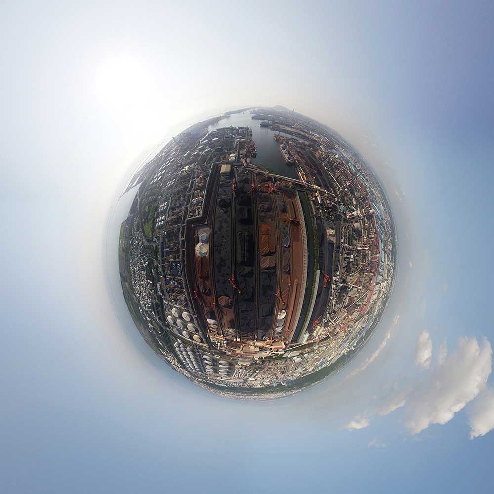
FENG Wei-Chung , an artist based in Taizhong, uses drone equipped with 360 degrees panorama technique to document the landscape of Taiwan’s east and west coastlines, revealing a vast contrast between them due to long-term human intervention. The six photographs show an industrial landscape in the west coast versus a pristine natural landscape in the east. The exhibition space is installed with a VR headset which the visitor can wear to view the landscape and move around to simulate the drone-view in the air. Whatever appears in the visitor’s view is projected unto the screen so that other visitors can see the same view. Thus two different views are experienced: one is of the VR wearer whose first-person 3D vision is virtually connected to the drone-body, and the other is of those seeing the 2D representation of that vision on the projection screen. This mixture of 3D experience with 2D representation has become a main vision in the development of urban verticality. As human society endeavours to reconfigure its kin to nature, to other species, and landscape as well as cultural space, the mixed vision of the vertical will be the key to this new relationship. In FENG’s exhibition space, the 360 degree VR experience also contrasts with those photographs on the wall in a fundamental way: whereas the former offers a floating, non-linear, safe yet unstable drone-body experience, the latter “condenses” the 360 degree panorama into a spherical vision, in which the image expands from the centre to the distorted margins, intimating a microcosm existing in an unknown, chaotic macrocosm. *Pierre Belanger, Altitudes of urbanization, 2016 (Tunnelling and Underground Space Technology)
Exploring Tainan’s mystical “Moon World of Magnificent Longci” CHAO Jui-Kuang
To the southwest of Tainan, there lies a mystical world known to few called Niupu, Longci. I have been visiting here frequently over the past two years to observe, recognize, learn, and unlearn what I had known in the past.Whenever I came to Niupu, Longci, there was always a Crested Serpent Eagle soaring in the sky. Sometimes, it flew through the valley around, and other times it was just a little black dot high in the sky. I wonder what it looks like if I saw this piece of land through the eyes of the Crested Serpent Eagle.I can now leave the surface of the earth, roaming freely in a 3-D space, high or low, near or far. My scale of life extends from dozens of meters to kilometers. I can see more details of things. I can follow the ridge of a mountain or a river out of curiosity, and appreciate carefully the outlook of this land. As I am no longer seeing the earth from the perspective of mankind, I discover more landscapes and details that I could only walk through but never be able to see previously, realizing the limitation of my prior knowledge or the sharing of false information as well as ignorance in the past.
The natural landscape of Niupu, Longci is the epitome of the natural landscape’s evolution of the west plain of Taiwan. Here, both time and space are condensed into one area, depositing stories of the evolution of Taiwan’s landscape over the past millions of years. There exists an ecological epitome of the expansion of the west plain of Taiwan as well as biodiversity. There are signs of climate change and environment change at present and in the days to come, together with scenes of adaptation to the climate change.Here we have extraordinary terrain. The vast 340-hectare land is kept intact for its history as the location of Longci Ammunition Factory. Today, the factory has been out of business for years, leaving the whole natural and industrial landscape behind, a well-preserved example in Taiwan. The whole area is a badland commonly referred as Moon World. The badland is formed because of its ever-changing terrains, mudstone, green limestone,sandstone, and gravel deposits that are easily eroded, together with the unearthed shells and the release of salts. A variety of compositions formed the diverse mountains and valleys. The surface is scoured severely in the rainy season, but is extremely dry during the dry season. It has four distinctive seasons. The terrain changes drastically as the earth keeps rising. There are Longchuan Anticline, Longchuan Fault, Gutingkeng Anticline, and numerous unknown blind faults. Hence, horizontally-packed geological lamination that is lifted and altered to almost 90 degrees, complicated cutting lines, fractured zone, and fault gouge can be seen. Gentle slopes formed by scoured soil from steep face of mountains can be seen from hills to the gentle alluvial plain. There are also taiga and savanna as well as Japanese silvergrass and bare land. Niupu Creek during the rainy season will become a grey, white river, and shrink to a tiny stream that forms a shallow water, a moisturized creek valley and totally dry riverbed in the dry season. Thanks to its ever-changing nature, a diverse environment is thus born with rich biodiversity. Further, since there was little man-made development, it becomes an ecological green ark of Taiwan’s west plain. Class-two protected animal Formosan Masked Civet, Crab-eating Mongoose, and Formosan Pangolin are commonly seen here along with numerous animals. There is also an old Mango tree with a girth over 440 centimeters, the largest in Tainan City.
Previously we only thought from the perspective of humans, not knowing, not understanding it along with ignorance and neglect. Furthermore, the government today granted permission to a construction of Landfill & Industrial Waste Management Center at the upstream of Erren River. So many places you could choose, and yet you chose a place at the upstream of a river in a well-preserved natural environment without pollution. Besides, choosing a site rich in natural and industrial cultural landscapes located on a geographically sensitive area that has landslide as the landfill site is something implausible in the advanced countries! The management and ultimate disposal of industrial wastes should be located nearby an industrial park’s industry chain. The idling lands at present or lands already polluted are the best, so you do not have to transport wastes all the way into the mountains. The old policies are insanely ridiculous. As long as it is not done yet, it is never too late to stop it. It should be designated as a geopark, or a natural preserve, or a national park. As such, I hereby call for considerations and actions of all. Tell more people, lobby officials and legislators. In the face of such splendid landscape, think about what you want to leave for kids, a glorious natural environment in abundance of Taiwan or a landfill full of pollution that destroys natural environment?
The Earth is Like a Mirror CHAO Jui-Kuang
Seeing from above, the earth is like a mirror.
You feed rice, it grants you golden waves of rice.
You sow seeds, it yields you sweet fruits.
You pour clean water, it awards you fish and shrimps in abundance.
The earth is like a mirror, reflecting how we treat it, no disguise but truthfulness.
This is the sight of Taiwan now. We fill farms of fish and crops with loads of industrial wastes illegally, creating astonishing appearances in variety. All these could be processed in accordance with regulations. It is safe and reusable though it comes with certain cost. Taiwan is sloppy with loose law enforcement, along with pressure or involvement of legislators, so here you see a profusion of colors. All these will come back to us eventually through the food chain.
What we see in the mirror is merely a warning from above.
On the Other Side of the Mountain FENG Wei-Chung
British poet William Blake’s Auguries of Innocence reads: To see a world in a grain of sand / And a heaven in a wild flower / Hold infinity in the palm of your hand / And eternity in an hour. This poem tells us that the universe an individual sees is subjected to the perspective and angle he takes. A big rock is a planet in the eyes of an ant; yet, the ant does not know it. An ocean of flower is the universe in the eyes of a butterfly; yet the butterfly does not know it, either. As the body is trapped inside, the eyes fail to see the world outside, in which it is located. Should the heart dwell in desires, one fails to sense where he is. Hence, people, unable to see themselves in danger, lose the most fundamental sense of judgement as well. In Taiwan, a small island it is, on which the Han people in the west coastline leads a life of profit and competition. They fill the ocean to reclaim lands from the Nature. They develop industrial parks as a tribute to the magnificent industry that ushers in economic prosperity and satisfies the material desires of mankind, unable to acknowledge the fact that they are living on an ugly, deteriorating planet. Whereas the indigenous peoples in the east coastline preserve a more primitive, environmentalist, self-sustained tribal ecosystem, in awe to Mother Nature. They live in harmony with the Nature. Although a simple lifestyle it is, they are living on a gorgeous planet full of hope. Through the unique perspective of a 360-degree panorama camera, a small scale of landscape around us is spherically projected and morphed into a planet of its own. Taiwan has always been situated in drifting status of uncertainty ever since ancient times. The outlook of the society through industrialization over decades under the influence of capitalism is manifested in the surreal map of the small planet, so that the spaces in the east and the west coasts together with the environment may engage in a dialogue. The struggle between the industrial planet and the natural counterpart, the unbalanced regional development of the small island, the tug of war between farmland and factory as well as the indifference among people in the crowded cities, as if we live in a crowded universe yet aloof and desolate like a planet afar. The outer world is in truth the image projection and extension of people’s inner world, and the image is the reflection of the real world. In an attempt to go beyond the vision and perspective of humanity, the artwork captures the footages and images of Taiwan’s environment as it is via the experimental 360° camera drone for audience to see the real universe around us.
Herbal Urbanism: Beitou is organised in collaboration with the Honggah Museum, affiliated with and co-funded by Topography of Mirror Cities. The Topography of Mirror Cities project, featuring in Dhaka, Bangkok, Taipei, Jakarta, Kuala Lumpur and Phnom Penh, is conducted by Sandy Hsiu-chih Lo as chief curator, and funded by the National Culture and Arts Foundation, Taiwan. Special thanks go to the Honggah Museum and Sandy LO Hsiu-Chih.
Curater: Manray HSU
Dates: 2018.06.10-07.15

On the Other Side of the Mountain
On the Other Side of the Mountain
FENG Wei-chung

The beautiful Longchi Moonworld
The beautiful Longchi Moonworld
CHAO Jui-Kuang

Exhibition View
Exhibition View

展出現場
展出現場

Exhibition View
Exhibition View

Exhibition View
Exhibition View
